I. G. Harmond is a civil engineer with over 35 years’
experience in consultancy. He has spent the past 15 years
managing a small firm specialising in environmental and water
engineering projects in the developing world. The following
article is based on his, lecture to the Society on 12 December
2001.
Introduction
The Soqotra archipelago is situated in the Gulf of Aden, some
400 km from Mukalla, and comprises four islands: Soqotra (125 km
by 42 kin), Abd Al Kuri, Samah and Darsa. The latter is
uninhabited and Abd Al Kuri and Samah are sparsely populated.
The archipelago’s total population is believed to be about
40,000. The highest landfall is on Soqotra, reaching about 1,500
metres above sea level. The islands were administratively part
of the Protectorate of South Arabia which attained independence
in November 1967 as the People’s Republic of South Yemen. With
unification in May 1990, they became part of the Republic of
Yemen and are administered by the Governor of Hadhramaut. Local
government authority is exercised through Hadibo and Qalansiyah
districts.
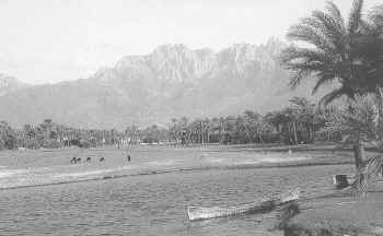 |
View of the
Haggier mountains from east of Hadibo |
The Master Plan
To accommodate and manage future economic and social
development on Soqotra, the European Commission, in January
2000, appointed a consortium of international and Yemeni
consultants to prepare a Master Plan. Its primary aim was to
examine the current economic, social and environmental
conditions on the island and determine how its resources could
be sustainably exploited for the good of all.
Phase 1 of the Master Plan comprised a series of sectorial
studies using existing data and drawing on the experience gained
from past and current projects. These included improvements to
Hadibo harbour, safety works for the newly constructed airport,
and activity in several other development sectors. I. G. Harmond
Associates Ltd were concerned with water resources. Priorities
were selected in consultation with the European Commission and
the Government, which were worked up in detail to form the basis
of Phase 2 of the Master Plan. Surprisingly, water resources
were not included in the Phase 2 sub-projects which concentrated
on institutional support to local authorities, environmental
management, zonal regulation, roads, fisheries, tourism,
livestock and land-use mapping. The final workshop to present
these has been put on hold as a result of international
political uncertainties.
An important development initiative running in parallel with
the Master Plan is the five year Global Environmental Facility
(GEF) project. This was launched in October 1997 and is managed
by the UNDP’s Office for Project Services in close
consultation with Yemen’s Environmental Protection Council.
Maintaining the delicate balance between economic and social
development, and the preservation of the island’s natural
vegetation poses serious challenges in the future. Ultimately
lack of rainfall and poor agricultural soils may prove Soqotra’s
salvation; for these factors will certainly limit internal
development such as crops and livestock production, and are
likely to inhibit development from external sources such as
tourism, light industry etc. The Master Plan took full account
of these factors in the formulation of a development strategy.
Water Resources Overview
Along with all other natural resources, the water resources
of the Soqotra archipelago are held in trust by Government on
behalf of the people. Government has a duty to frame and
implement laws which will ensure that people, agriculture and
industry all have access to adequate supplies of water for the
foreseeable future. But the challenges in meeting this goal are
immense. It is a commonly held misconception of many who frame
water policy that supply deficits can largely be met by building
infrastructure such as dams and pipelines. But the only viable
long term solution lies in water conservation, regulation and
self-help. Rural water resources strategies, therefore, must
focus and support this approach.
As regards agricultural output, there is a widely held belief
that Soqotra could become the country’s ‘bread basket’
(Vol.2, First Scientific Symposium on Soqotra Island, Aden,
March 1996). This euphoric view could not be further from the
truth. Rainfall which runs off to the sea, if dammed or
diverted, could be used to irrigate substantial areas. But the
engineering works needed to do this safely are considerable, and
either uneconomic or unsustainable. And even if water in
sufficient quantities could be delivered — at the right place
and time — this is only part of the story, as soils, access to
markets, and, not least of all, skilled farmers are needed to
make irrigated agriculture cost-effective.
Spate diversion schemes, like those engineered and
constructed on the mainland, are technically complex, and,
again, skilled farmers/water user groups are needed to operate
and maintain them. The same would apply on Soqotra.
In addition to water projects for drinking and agricultural
use, there are other schemes which will have an impact on any
future water development strategy. For example, the airport,
when completed, will generate a considerable demand for water,
as will any new tourist hotel, port facility, fisheries or
commercial enterprise. They will all have to be catered for,
either by enlarging existing resources or by identifying and
developing new ones. There are pressures on Government to
undertake large scale agricultural projects in Soqotra. However,
unless markets can be found and a technology employed which
takes account of poor soils and little rainfall, these are
unlikely to prove economically viable. Nevertheless, this
situation could change in the future with the construction of a
deep water port which allowed a high value irrigated cash crop,
such as citrus or mangoes, to be grown and exported to the Gulf
states.
There is little doubt that water has a high priority in the
aspirations of the local population. A survey carried out for
the Master Plan in 64 areas during November and December 1999
indicated that drinking water and facilities for the
distribution of water were major popular concerns; only health
ranked above them.
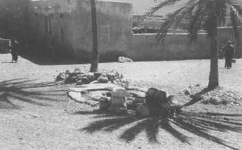 |
Well-head,
Qalansiyah, north-west corner of Soqotra.
Photograph: I G Harmond |
Water Resources and the Law
A new water law has been before Cabinet for some time —
largely the work of the National Water Resources Authority. This
is believed to stress the importance of water for economic,
social and cultural development, and to emphasise the need to
conserve and value the resource. Cost recovery — a vital
ingredient — is thought to be the major ‘sticking point’.
The law will deal with licensing, abstraction, conservation and
water transfer schemes. There are likely to be subsidiary
guidelines on water sharing between agriculture, industry and
potable use, asset management, water pricing and cost recovery.
No charges are currently levied on the use of water for
agriculture or drinking (except for the latter in certain urban
centres on the mainland), but, in theory, official permission is
required for abstraction and transfer schemes. A new Local
Authority Law with a number of water-related clauses was passed
in January 2000 but its impact on national water policy remains
unclear.
The Department of Electricity and Water is responsible for
water and power utilities, while the Department of Agriculture
and Water Resources is responsible for broader water issues. Not
surprisingly, these departments are understaffed and
under-resourced; poor living and working conditions are said to
be the primary reasons for their failure to attract qualified
staff.
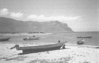 |
Khawr Mityaf,
south-east corner of Soqotra.
Photograph: I G Harmond |
Water Resources: Facts and Figures
Weather on Soqotra is dominated by the north east winter
monsoon (October to April) and the south west monsoon (May to
September). Nobody has a clear idea of what the rainfall for
Soqotra might be, and a figure of 170 mm per annum is widely
quoted, based on northern coastal plain readings as there are no
gauges on the southern side. The level of rainfall in the
Haggier mountains (1,000 rising to 1,500 metres) and the
western, central and eastern plateaux (100 rising to 1,000
metres) is unclear. It might be as high as 1,000 mm per annum;
this is informed speculation, and logic suggests that it would
be higher than the commonly cited figure of 170 mm per annum.
Nevertheless, a study carried out in Dhofar — which is
geographically and climatologically similar to Soqotra —
indicated that rainfall actually reduced, the higher one
travelled up the catchment.
Exceptional rainfall in late 1999 and early 2000 caused
prodigious damage to property and livestock. As could be
expected, the impact was greatest in villages situated along the
edge of wadis. 1999 is a good indication of how confusing
meteorological data can be. The usually rainy months of May to
June were, in fact, very dry, and severe drought was experienced
across most of the island. Extension officers (32 in number)
working with the GEF and constantly moving around the island,
compiled a set of animal statistics which showed that some 70%
of all livestock perished in the drought. But when one adds the
equally catastrophic storms which occurred in November and
December into the annual total (about 630 mm of rain fell in 22
days), 1999 was the wettest year on record for a long time.
Soqotra is said to be ‘devoid of major aquifers capable of
sustaining substantial development’, and the limestone
deposits are believed to provide very little water as the ‘retention
line is often short’ and the rock makes excavation difficult.
Water quality varies considerably around the island, and clearly
the closer the resource is located to the sea, the more likely
it is to be saline. Numerous water samples have been taken and
analysed over the years and confirm that much of the ground
water used on the island is saline. The further inland one
travels, the greater the likelihood of finding potable water of
reasonable quality.
There is ample evidence of perennial springs providing some
communities with potable water, and, more often than not, its
quality is good. But water from shallow wells — common along
the coast — is more problematic. Some hand-dug wells (2—4
metres deep) strung along the wadis provide inland communities
with water, but this is mostly seasonal and for many months of
the year the wells are dry. During periods of high rainfall,
considerable run-off occurs along the wadis, and there would be
ample scope for ground water recharge structures.
On Soqotra the soils are generally poor, as shown by the
vegetation which has adapted itself to survive in semi-arid
situations with low rainfall. The only exceptions are in wadis
along the northern and southern coastal plains, which open out
to form relatively fertile alluvial fans. Here date palms are
often grown, supported by supplementary irrigation from ground
water.
No data could be found on plateaux soils, which only support
light grasses and some very special endemic tree species. These
soils have little or no agricultural potential and are rapidly
grazed off by livestock owned by pastoralists moving from one
water point to another. It is debatable whether it was lack of
grazing or lack of water which caused the disastrous loss of
livestock in 1999, but most probably it was a combination of
both. In the Haggier mountains there is little or no soil to
speak of, and silts washed down and held in wadi depressions
have limited agricultural potential.
The only conclusion to be drawn from examining the soils and
observing the forms of agriculture practised on the island is
that very little potential exists for large scale development.
On the other hand, the natural vegetation of the island is
unique, and many plant species — long since extinct in other
parts of the world —can only be found there. It has been
studied and observed for a long time, with the most consistent
work on the plant life and biodiversity of Soqotra carried out
by experts from the Royal Botanic Gardens, Edinburgh, who have
acted as consultants for both the UNDP’s GEF and the Master
Plan.
There are thirteen major wadi catchments on Soqotra and these
were used to determine flood flows. The estimated area, stream
length, maximum elevation and slope for all thirteen catchments
were used to construct a computer model, which generated flood
peak flows on the three main catchments (Wadi Demaleh, Wadi
Rahmum and Wadi Diyada) of 37, 42 and 489 cubic metres per
second respectively. This was a pilot exercise, and at some
later stage a full computer run will be needed to calculate
flows for all thirteen catchments.
Potential rain water yields from surface catchments,
including kareefs and tanks, were analysed, and these systems
can be effectively developed to meet animal and potable demands.
But high evaporation and percolation rates from tanks will limit
their application, unless a cost-effective covered and/or sealed
unit can be designed. Small scale desalination systems were also
considered but the cost of these would restrict their use to key
demand centres such as hospitals, clinics and hotels.
Possible projects for renewable energy were examined:
windmills, ram pumps, solar cells, turbine wheels for generating
low voltage electricity and raising water, and low cost water
desalination plants that use sunlight to evaporate and condense
water vapour. However, most are costly and locally
unsustainable. For a hospital or health centre where electricity
is needed for keeping drugs, solar systems are possible, but in
a rural context would offer few advantages.
Setting and implementing objectives
The Master Plan incorporates a time frame for implementing a
set of principal objectives. In the context of water resources
these include:
- Increasing living and health standards by identifying,
utilising and conserving resources
- Sustainable economic growth by providing secure and
reliable water supplies;
- Protection of the island’s unique biodiversity.
To implement these objectives ten water sub-projects were
identified:
- Hydrometeorological database network;
- Water resources master plan;
- Wadi basin management plan;
- Small weir and reticulation system for Wadi Airi;
- Water harvesting systems for agriculture and kareefs;
- Small spate irrigation schemes for agricultural
production;
- Wadi canalisation and village flood protection works;
- Sand storage dams for agriculture and potable water
supplies;
- Spring protection works for potable water supplies;
- Jetted ground water extraction in wadi beds for potable
water supplies.
Conclusion
Water projects are only sustainable where communities are
mobilised and a self-help approach is adopted. But implementing
such projects through existing district departments will be
difficult due to a lack of institutional capacity. Unless these
departments are strengthened through training and the provision
of additional resources, or by engaging the private sector, the
inevitable outcome will be project failure and, worse still,
popular disillusion.
Meanwhile, problems are likely to be experienced in
reconciling potential water projects with the GEF zoning plan.
The latter has been prepared by scientists, and takes little or
no account of the need to accommodate a rapidly increasing
population (estimated to double within 20 years) and the
potential water deficit. Indeed, there is no mention of water
resources projects in the nine development activities prescribed
in the GEF zoning plan summary.
Finally, it is worth mentioning that on 25 August 2001 the
inaugural meeting of ‘The Friends of Soqotra’ was held,
attended by thirty two people. This is, essentially, an
international gathering of technical experts and enthusiasts ‘committed
to balancing scientific investigation with bringing direct
benefits to the Soqotri people’. It is a very commendable
initiative which should be supported by all those with an
interest in the social and environmental future of the Soqotra
archipelago.
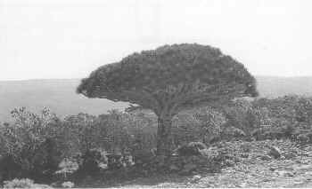 |
Dragon's Blood
tree (Dracaena cinnibari), Soqotra.
Photograph: I G Harmond |